.gif) Ardabil
Ardabil
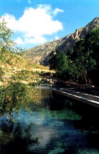
Khalkhall
The city of Khalkhall is located in a mountainous region south
of the province, 549 kilometers from Tehran. The climate of the city is very cold
in the eastern parts and moderate in the north and south. The Tallesh Mountain
Ranges extends from eastern Khalkhall southward as a barrier between the Caspian
Sea and Gilan and Azarbayjan provinces causing less annual precipitation in western
parts, compared to that of eastern side, with poor vegetation. There are rich
pastures, resort areas, eye-catching landscapes and natural promenades around
the city.
Meshkin Shahr (Khiyav)
The city of Meshkin Shahr is located in the northwestern Iran, at the center of the province, and 839 kilometers far from Tehran. Being near the high Sabalan Mountains it enjoys a moderate mountainous climate. Formerly, it was known as "Khiav". The Sabalan summit can be seen in the south of the city with an eye catching scenery. The antiquity of the city dates back to the early centuries of Islam but in the Safavid age it was thriving even more.
Sabalan Mountains, Ardabil
One of the most interesting mountains of Iran, with an altitude of about 4,800 m., is Sabalan which is originally a volcanic mountain. The summit is located 41 km. from Ardabil and can be easily observed while traveling on the road to Sar Ein and Ardabil. There is a lake on top of the Sabalan Mountain, which is a major attraction for professional hikers.
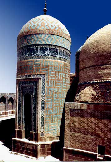
Sheikh Safi-edin Ardabily Mausoleum, Ardabil
It is composed of a series of monuments built in various periods that was shaped as a complex for the first time by Shah Tahmasb. Later Shah Abbas added to the previous ones and renovated some sections. This historical complex is closely intertwined with the history of the Safavid Dynasty. Some of the Safavid kings as well as Shah Esmail I have been buried at this site. The main section of the mausoleum is composed of a circular tower with circumference of 22 m. which is about 17 meters high. In the interior of this monument, near Sheikh Safi's tomb, the tomb of his son (the founder of mausoleum) and those of other family members can be found. Page Contents
At the time of Naseredin Shah Qajar, i.e., about 115 years ago, major renovations took place and some changes were made to the complex. This site has been a major attraction for domestic and international tourists.
Main sections of the complex are the followings: the gate, the large court, the small court, the graveyard court, Shahidgah (martyrdom place), Janat Sara Mosque and Cheleh Khaneh which encircles Qandil Khaneh, Haramkhaneh and Chini Khaneh. The Allah Allah Dome is very famous and probably the most spectacular part of the complex.

Bushehr
Bushehr
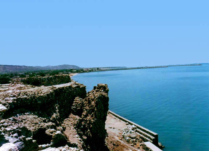
The township of Bushehr is located in a vast plain running along the coastal region. The capital city being Bandar-e-Bushehr or the 'Port of Bushehr'. This port is at a distance of 1,218 km. from Tehran, and has a hot, humid climate. Since the past, this port has been one of the important ones in Persian Gulf which has an international airport too. During the 1st and 2nd Millennium BC., the Peninsula of Bushehr was a thriving and flourishing seat of civilization called 'Rey Shahr'.
Many relics have been found in this regard related to the Elamite era and the civilization of Shoosh. These structures of "Rey Shahr' are said to be related to Ardeshir Sassanide and Rey Shahr was formerly known by the name of Ram Ardeshir. Thereby through the passage of time came to be called Rey Shahr and thence Bushehr.

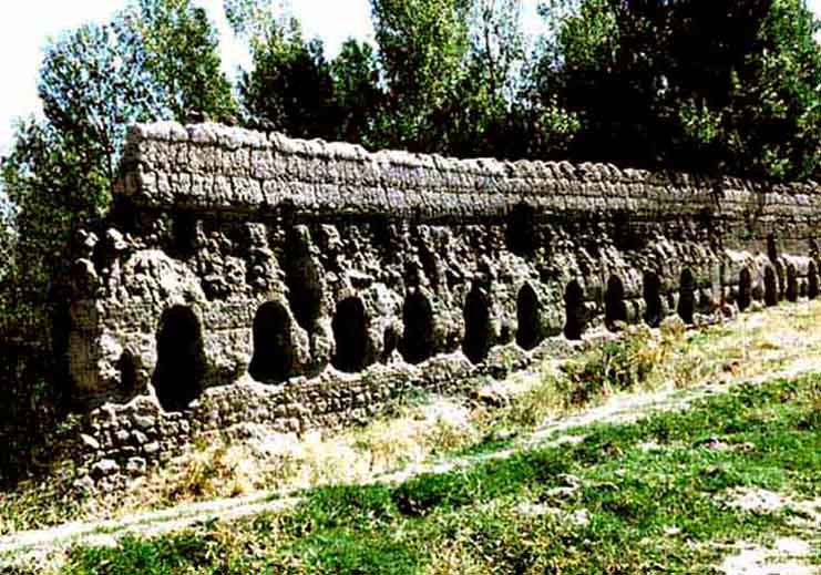
Dashtestan (Burazjan)
This township is in the north of Bushehr, its center being 'Burazjan', which lies at a distance of 1,147 km. from Tehran. Dashtestan experiences an extremely warm climate and in past was known as 'Shabankareh' its center is the ancient city of 'Eij'. Burazjan was one of its basis, where there are the remnants of an ancient castle.

Genaveh
Bandar-e-Genaveh lies on the coastal waters of The Persian Gulf, between Bandar-e-Bushehr and Daylam. The current city of Genaveh has been constructed in the southern segment of the old city. Relics such as stone arches are evident in the ancient city.
Tangestan (Ahram)
Tangestan is yet another townships of Bushehr the center of which is 'Ahram'. The famous fort of Tangestan lies in this township, the inhabitants of which are distinct for their loyalty to the country and chivalry. It is believed that the vicinity of 'Tedumari' in Tangestan is a reminder of a trading clan reputedly from central Asia ,i.e., the ancient 'Tedmer' and 'Palmir' tribes. It is evident that the coastal region of the Persian Gulf was an important trading and commercial center for traders belonging to different areas in the past.

Chaharmahal Va Bakhtiyari
Shahr-e-Kord
The township of Shahr-e-Kord is located to the northeast of this province, Shahr-e-Kord being its capital city and situated 543 km from Tehran. Shahr-e-Kord is in the midst of a plain surrounded by mountains. In the 7th Century AH Shahr-e-Kord and its outskirts came under the rule of the Atabakan-e-Fars and Lurestan. It was in this area that a sentry post was set up to control both passenger traffic and see to their need. The Kords formed the guard of this post, thereby this vicinity was known as Dehkord. After many decades due to its expansion Dehkord was named Shahr-e-Kord and is reputed for its fine weather and natural beauty.

Zaman Khan Bridge, Shahr-e-Kord
This bridge has been constructed on the Zayandeh Rood River at the distance of 29 km northeast of Shahr-e-Kord. This bridge has been built by one of the tribal chieftains named Zaman Khan. This bridge has been repaired twice, once in the year 1022 AH during the Safavid era and for the second time in the year 1321 AH by Haj Abdol Hossein Qazvini, the owner of the Jamali Village.
 
East Azarbayijan
Kabood (Goey) Mosque, Tabriz
This structure is the remnants of the Turkamans in the year 870 AH. The mosque was destroyed by the earthquake in the year 1192 AH. and only the gateway remained as an excellent piece of architecture. The building of the mosque became under interest in 1310 AH. and in 1318-1319 Shamsi (1939-1940) and after the Islamic Revolution, its northern facade was reconstructed.

Tabriz
The city of Tabriz is situated 619 km. northwest of Tehran and 150 km. from the borders of Iran and the Republic of Azarbayjan. This city is generally cold but due to its environment the climate is extremely pleasant. Rivers such as Ajy Chay, Liqvan Chay, Maidan Chay and Soofian Chay flow through this area. In an inscription related to Sangar II one of the Assyrian rulers 714 BC, the name of Tabriz has been mentioned in the 3rd and 4th centuries AD when the city of Tabriz was of great importance.
For the first time in the 4th century AH., the Raavadian family proclaimed Tabriz as their capital. During the said period and the Mongol reign, Tabriz experienced many earthquakes causing it to become a ruined city. But after the Mongol conquests this city was made capital by 'Abaqakhan' of the Ilkhanan. During the reign of 'Mahmood Qazan' (694 AH.) the city thrived . Mosques such as Alishah, Robe Rashidy, and Shonab Qazan were constructed during this period. During the Safavid dynasty Tabriz was the capital of Iran. The Kabood Mosque is a relic from the time of the Turkamans. In later centuries Tabriz has been the seat of great warriors facing the Ottomans and Russians.
Personalities such as Sattar Khan and Baqer Khan in their fight against despotism is on historical record. In the year 1911 AD., Sheikh Mohammad Khiyabani (one of the clergymen) revolted against the colonialist policies of the British government. The Islamic revolution owes its success partly, because of the participation of the people of Tabriz and their heroic deeds.
 
Esfahan
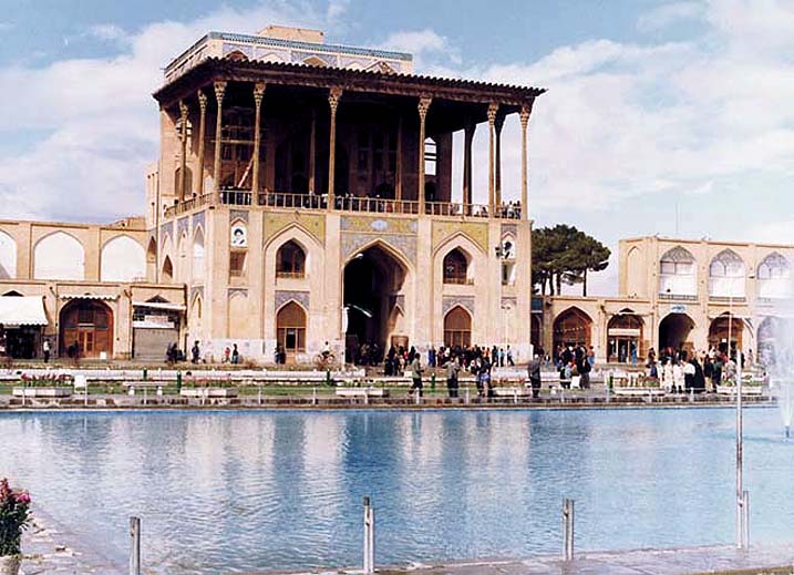
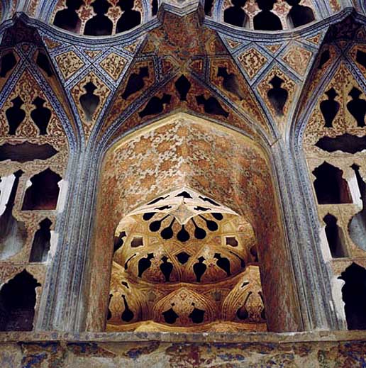
Ali Qapoo Edifice, Esfahan
This palace was also called 'Daulat Khaneh-e-Mobarakeh Nagsh-e-Jahan' and the 'Daulat Khaneh Palace'. Its unique archaic architecture is related to the Safavid era. This edifice was constructed under the orders of Shah Abbas I. The monarch would receive special envoys in this palace and hold his audience here. Valuable miniature paintings, the works of the reputed artist of the times Reza Abbassi, and other traditional works of art can be noted here.
Plasterwork of the 'sound room' was modeled such that the acoustic affect produced natural and pleasant sounds. The sovereign and his guests would be spectators to polo, illuminations, fire-works and the dramatics that took place in the Nagsh-e-Jahan Square from the halls of this elegant palace
Chehel Sotune Palace, Esfahan
The Chehel Sotune Palace and its garden cover an area of approximately 67,000 sq. m. This palace was constructed during the reign of Shah Abbas I. Shah Abbas II was also responsible for additions to this palace, such as the hall of mirrors, the hall of 18 pillars and two large chambers facing the north and south. The spectacular hall of mirrors with its decorative mirror work, tile work and paintings, along with its majestic porches and pool which faces this hall, all add to its splendor.
Interesting aspects of the Chehel Sotune Palace are:
The stone lions at the four corners of the central pool, the hall and marble and vaulted cornices around it. Paintings of Chehel Sotune Palace
The gilded adornments, paintings and the portrait of the sovereign in the royal hall. Along with that of the chambers surrounding the hall of mirrors.
The portrait of Shah Abbas I with the special crown and the miniatures of the treasury room.
Several facades such as the 'Qotbiyeh Mosque', 'Zaviyeh in Kushk', and the imprints of the 'Dar-e-Joubareh' and 'Aqasi Mosque' are affixed in the western and southern walls of the garden. The hall and porches of this palace were constructed during the fifth year of the reign of Shah Abbas II. The reflection of the twenty pillars of the hall in the pool opposite the palace brings about a conception of forty pillars. Hence the name Chehel Sotune.

Menar Jonban Minaret, Esfahan
This structure comprises of a mausoleum and two minarets, constructed on the tomb of 'Amoo Abdollah' a reputed personality of the 8th century AH. The tombstone reveals the date 716 AH., coinciding with that of the reign of 'Oljaito' Ilkhan the Mongol. It is extremely interesting to note that on shaking one minaret, not only does the other move, but that the structure itself sways.

Sio Seh Pol (Allah Verdy Khan) Bridge, Esfahan
This bridge is approximately 300 m. in length and 14 m. in width, and is one of the masterpieces in bridge construction in Iran and the world. The same was constructed in 1005 AH. under the supervision and expense of Allah Verdy Khan, one of the famous commanders of Shah Abbas Safavid I. The Armenians used to hold special festivities near this bridge in the Safavid period. It was constructed on the Zayandeh Rood river.

Fars
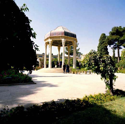
Hafiz Tomb, Shiraz
Hafiz is one of the most famous Gnostics and poets of Iran, who was born in Shiraz in 726 AH and passed away 65 years later. The tomb of Hafiz also known as Hafizieh is located north of Shiraz and comprises of two gardens. Many people still come to pay homage to this master of poetry. The mausoleum itself is located in a lovely garden, and has an atmosphere of peace and calm that is quite unique.
Pasargadae, Marvdasht
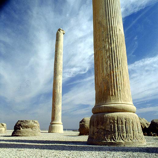
This palace is 600 meters to the northeast of the Koorush shrine. The area of this palace is 2,620 square meters and includes a large hall (with eight columns) in the middle and four terraces in four directions and two rooms in the corners. To the east of the palace is Pasargadae, composed of a large hall with eight columns. There is a doorway on the north, east and western side of this hall. In the northern doorway, there is an impression of a winged human with two wings directed towards the sky and two wings to the bottom. Where as the hands are raised towards the sky in a gesture of prayer.
This edifice with 3,427 square meters area, is located 15 km. northwest of the palace. The main hall has 30 columns made of white stone. A mass of black and white stones have been used as construction material. One of the characteristics of Pasargadae is the canals made of white stone, which were used, for irrigation.
There are equally other remains distributed in the province, some registered as national heritage monuments. These include the ruins of the Achaemenian Dynasty (Saravan Village), the Dokhtar Palace (Rastaq Village) dating back to the 3rd century AD, the restored Sassanian Palace (Sarvestan) dating originally back to the time of Bahram Gour (year 420 AD), Ardeshir Babakan Palace (Marvdasht).
 
Persepolis (Takht-e-Jamshid), Marvdasht
On top of the rocky mountain of Rahmat in the plain of Marvdasht, the ruins of Takht-e-Jamshid palace are pre-eminent. Construction of these palaces started at the time of Darius I (521 BC) and was not completed in less than a period of 150 years. Takht-e-Jamshid is registered as a World Heritage Site by UNESCO.
Persepolis (100 Gate Palace)
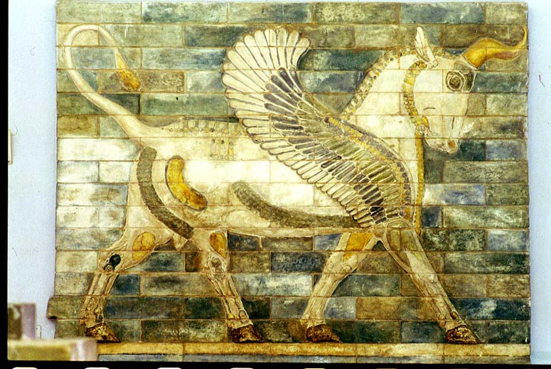
The entrance of the complex is formed by a two-ramp stairway composed of 110 rather wide and short steps. On top of the stairways is the main entrance or �The Great Gate�, marked by two statues of a bull with a human head and a pair of wings. There are two exits, one to the south and the other to the east. The south exit or gate connects to the Apadana Palace.
Takht-e-Jamshid is 125 thousand sq.m. in area, and is composed of the main sections:
Official reception halls and palaces Persepolis (Nation Gate Palace)
Smaller and more private palaces
Royal treasury
Private fort and special fortification
Various edifices or palaces that have been built are as follows:
The Small Palace or the Gate of All Nations
The Apadana Palace
The Palace of Darius,(one of the primary palaces constructed on the Takht-e-Jamshid rock, which was also called the "Tachar" Palace.) Pillars of Persepolis
Hall or palace of a Hundred Columns
The Semifinished Gate or palace
Treasury of Takht-e-Jamshid
The Three Doorway or Consultation Palace or Hall
The stone well
Tombs of Ardeshir II and III
The Palace of Khashayar Shah (called �Hadish�)
Takht-e-Jamshid was set ablaze by Alexander the Greek (330 BC) after which only ruins have remained. From these ruins, the Apadana Palace, at the main entrance, with 36 columns and three balconies (12 columns in each) in the north, south and eastern sections of the palace have been remained. The northern and eastern terraces are connected to the gardens opposite. The height of the platform in the Apadana Palace is 16 m. and the height of its columns is 18 m.
 
Sa'di Tomb, Shiraz
Sa'di, a keen traveler and famous Gnostic, was a known poet of the 7th century AH. he was born in Shiraz and passed away between the years 695-691 AH. In 1942, the present building was constructed by the Association for National Arts and the tomb of Sa'di was placed in an octagonal mausoleum with high dome and interesting tile works.
Gilan
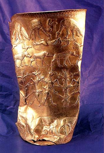
Marlik Archaeological Region, Roodbar
On the eastern fringes of the Sefid Rood River in Roodbar,is a beautiful valley called 'Gowhar Rood'. Nestling in this valley are both large and small archaeological hillocks. Amongst which are the 5 hillocks of Marlik, Zainab, Beejar, Peelaqaleh and Jazemkool. These are vital and valuable remnants. Marlik is a natural hillock and its rocky structure reveals rich composites of iron sulphate.
Some research workers believe that Marlik has attained its name from the innumerable snakes that have inhabited it. (As 'Mar' means snake in the Persian language). Whereas, some believe that the treasures of Marlik are related to the Amard clan. In the studies performed on this site, a large number of broken earthenware pieces can be noted. Moreover, in the excavations carried out two tiny statues of cows in admiralty metal, two cylindrical seals, fourteen gold buttons and other unique objects have been discovered. In this hillock, there is the remnants of a quadrangular structure with an approximate area of 30 sq. m. the same probably being a tomb or temple.
This hillock was also a site where the local commanders or princes who ruled in the 2nd or 1st millennium BC. were laid to rest. According to the tradition of the times, the dead were buried along with their treasures. About 25 tombs have been discovered, in some of which are human carcases, besides which, articles such as earthenware and bronze vessels, decorative buttons, arrows, swords, spears, bronze and earthenware statues, daggers, hemlets and ........ have been discovered. Fabrics from this site have come to hand that determine the fact that weaving was a progressive technology in Iran thousands of years ago, and more so in Gilan. About 11 seals have been discovered in these excavations, and these have interesting designs and patterns on them. There is a seal engraved in the Cuneiform script.
According to archaeologists, the same dates to a millennium BC. Excavations of Marlik are spectacular and outstanding in the world. Valuable articles such as, gold, silver and bronze cups, chinaware and mosaic have also come to hand. The Marlik Cup is unique and is 18 cm. in height and is of pure gold. The center of which reveals the pattern of the tree of life, with two bewinged cows on either side. At the base of the cup is a beautiful flower intricately engraved.
 
Masooleh Village, Fooman
This village is situated in the south west of Fooman, 63 km. from Rasht. It enjoys a moderate climate. Local architecture, springs, waterfalls, the 'Rood Khan' River and dense forests all make it an attractive tourism spot. Masooleh's integrated architecture and its houses are of two storeys. These comprise of an entrance corridor, cellers and other unique architectural features, and are linked to each other by a staircase. Such that the terrace of each house is the court-yard of the house above. The presence of the ancient Own Ebne Ali and Own Ebne Mohammad in Masooleh are pilgrimage sites and hold cultural importance.

Golestan
Golestan National Park, Gorgan
The Golestan National Park is the first Iranian National Park that is situated in the jurisdiction of Golestan, Semnan and Khorassan provinces. This park because of its natural values like verdant and virgin forest and different species of flora and fauna is one of the famous areas in Iran and the world. This park has been a protected area since 1957 under the name of "Almeh" and "Yashki" and in 1976, these two parts combined and became the Golestan National Park with 91,890 hectares in area.
This park is formed of slightly sloping hills and high calcareous rocks. Its climate is very damp and in some places dry. Some important areas around the Golestan National Park are: Loweh, Dasht, Takhteh Iran, Yan Bolaq, Gildaq and the Qorkhoud protected areas. The most important animals of the Golestan National Park are: Rabbit, tiger, golden eagle, wolf, fox, panther, bear, sable wild cat, wild goat, wild pig (bore), gazelle, ram, deer, venison, kinds of snake, kinds of fish, black dall, delijeh, pray birds etc. Most important plants of this park are: fig, mulberry, wild pear, walnut, raspberry, barberry, different medicinal plants etc.
  
Hamadan
Alisadr Cave, Kabudrahang
The said cave is the largest in the world, containing water and offering the use of canoes. This cave is located in the village of Alisadr, district of Kabudrahang, and was inaugurated in the year 1967. In the hills where the Alisadr cave is located, there are two other caves by the names of Soo Bashi and Sarab Caves. The water present in Alisadr Cave, takes its source from that of the Sarab Cave. The Alisadr Cave comprises of a number of small and large 'halls' or spaces, in a maze like fashion, connected to each other by passages.
The water within the cave is extremely cold but very clear, odorless, colorless and with an ordinary taste. It comes under the calcium bicarbonate category, is nearly neutral in PH, but unfortunately polluted. The ceiling of the cave is covered with a sedimentation of pure calcium carbonate and a mixture of other chemical compounds. Thus forming stalagmites of unique beauty and design, which draws the attention of visitors. The air within the cave is light and static.
To date, all the canals of this cave have not been discovered, and only approximately 2,100 m. have been recognized. Here, the height of the ceiling is between 1-35 m. the width of the canals 2 - 15 m. and the depth of the water 1 - 17 m. Within the cave, electric power, and paddling canoes (seating 4 persons) aid visitors to see parts of this cave.
 
Ganj Nameh Inscriptions, Hamadan
These inscriptions are relics from the period of 'Darius' and 'Khashayar Shah' of the Achaemenian era. The said are located 5 km. west of Hamadan at the end of the 'Dareh-ye-Abbas Abad' or Abbas Abad Valley, and have been engraved on a mountain. Each of these inscriptions have been segregated into three columns with twenty lines, and in three languages of ancient 'Parsi', 'Baboli' and 'Ilami'. The Parsi text is to the left of these two inscriptions, the Baboli text is in the center followed by the Ilami text to the right of the engravings. The engraved tablet to the left is related to Darius the Great, under which is the engraving related to the period of Khashayar Shah.
Hormozgan
Kish Island, Bandar Abbas
Kish Island (economic free zone) is located in the Persian Gulf waters, to the southwest of Bandar Abbas, and is an oval shaped island with an area of 89.7 sq. km. It has a length and width of 15.6 and 7 km. respectively. Its center for cultured pearls and large aquariums are one of the attractions of this island. Besides which its strand offers scope for other leisure such as a round in a glass-bottom boat, water skiing and scuba diving (with the aid of a guide). Shopping arcades prove interesting places and so too other recreational areas.
Portuguese Castle, Qeshm
This castle was built in the year 1030 AH. to the north east of this island under the decree of the Spanish monarch of the times. The same has two ramparts and towers in the four corners. Within the castle a number of extremely ancient and rusty canons remain to date.

Qeshm Island, Qeshm
This island lies to the north of Hormoz Strait, its length being 115 km. and its width ranging from 10-35 km. The city of Qeshm is its center, the same being in the northeast of this island with an area of 3 sq. km. and at an elevation of 10 m. above sea-level. The island is situated at a distance of 1,353 km. from Tehran and 12 nautical miles from the main land. Climatically it has one long warm and humid season, and a shorter moderate one. Its rocky coastal areas are favored by crabs and lobsters. Besides which, its forested vicinities such as Harrah (mangroves) Protected Area located between the north of the island and Bandar Khamir are wonderful sights to visit.

Ilam
Ilam
Located 710 kilometers from Tehran, the city of Ilam is surrounded by heights covered with forests enjoying a mild mountainous climate with very pleasant springs. In the ancient time, Ilam was known as Arboojan. Then, Ilam was known as Hossein Abad till 1929, when it was reconstructed. Hossein Qoli Khan, the most powerful governor of Poshtkooh, constructed numerous different buildings in the city that was his and successors summer resident. Regarding its historical background, in 1946. it was named Ilam by the approval of Iranian Academy. Presently, Ilam is the capital of the province and has developed considerably in recent years. Ilam is a very important city from the tourism point of view due to several natural, historical and cultural monuments.
Kerman
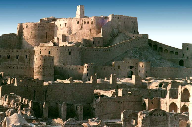
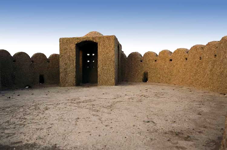
Bam Citadel, Bam
To the north east of the Bam city, in the skirts of a gigantic rock is the foundations of a fortified castle, reputedly known as the Bam Citadel. This citadel was actually the old city of Bam. The city comprised of four sections and 38 watch towers. In the southern side of this structure there were four ramparts and to the north-eastern section there was also another colossal rampart. The citadel has been constructed of sun baked bricks, argyle and straw, but in some parts stone, brick and the barks of date palms have been utilized. The said citadel comprises of the entrance gate-way, a public sector, a military base and the central section or seat of power.
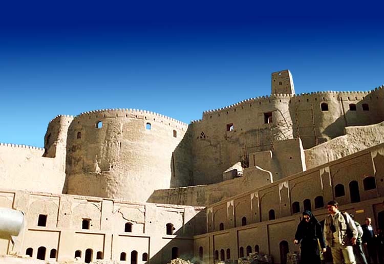
The public dwellings were constructed alongside the elevated areas and on the ground level. Regarding the city construction planning its a complete aggregate. Its distinguished areas are the main passage or bazaar, Hosseiniyeh (or place for public religious rituals and mourning), mosque (fire-temple), gymnasium for traditional sports, public bath and a religious sector pertaining to the Jews. Most of the common houses were constructed in such a manner that they were connected to each other and usually had interconnections. In some houses, private baths are seen. A few of these buildings are two storeyed structures which were most probabely constructed due to increased population. Bam Citadel
After the gateway entrance there is a main passage which leads to the second gate-way. A part of this route was the city bazaar. Remenance of a bakery, an oil extraction area and the mud made shelves of bazaar reveals the splendour of the city in that time. Running parallel to the main passage there were two other paths leading to the second gateway. The Hosseiniyeh or place for religious mourning comprised of a large area with a two storeyed symmetrical porch, a few chambers and three pulpits of sun baked bricks. The traditional gymnasium consisted of four porches, a dome and a low-lying area, surrounded by a higher platform. Bam Citadel
The Bam citadel has two mosques, one is the Jame' Mosque and the other the Hazrat Mohammad (AS) Mosque. There was also used to be a public bath in public section, which is unfortunately in a ruined state at present. After the second gate-way are the stables, rampart and the sentry picket. The third gate-way led to the garrison, the commanders residence and a wind mill. In the midst of the citadel, a three storyed edifice remains which was used to be the seat of the ruling power. Alongside this structure was a private bath of the commander, and a drainage conduit. This citadel was constructed by Bahman Esfandiyar, and dates back to the pre-Islamic period. The Bam Citadel has undergone several repairs.
Kermanshah
Anahita Temple, Kangavar
In Kangavar, on an elevated rocky platform, is the remnants of a majestic structure. The same belongs to the pre-Islamic era and was known as Anahita. The name of this temple is depicted from Anahita (Nahid) who was a deity and gaurd angel of water, abundance and blessing. Some believe that the structure dates back to the Parthian era, whilst upon this relic the evidences of this period and the early Islamic era can also be noted. According to scientific researches, the architectural characteristics of this temple have acquired inspiration from that of the Achaemenian age.
The main structure of the Anahita temple is a quadrilateral one. Its ramparts being 230 m. in length, and its thickness in most of the parts is 18 m. which reveals the archaic grandeur and magnificence of this structure. The stairway of the temple is bilateral and closely attached to the wall. The difference between the lowest and highest point of the structure is 30 m. and is in a form of steps, similar to the Achaemenian structures. At the foot of the eastern wall of the structure is a cemetery which is related to the Parthian era. It is noted that the deceased have been buried in such a way to face the Anahita structure.
 
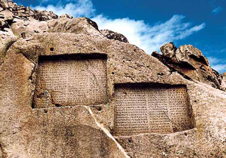
Bistoon Inscription, Bistoon
The primary scientific studies regarding the engravements and inscriptions of Bistoon were made in 1835, by Henry Rawlinson, a young British officer. After which this research was carried on by several scientists who added their discoveries to this historical treasure. The text of this inscription was engraved in the breast of the mountain in 522 BC. by a decree from Dariush. The same relates to the war which lasted for two and a half years, between him and his opponents in order to gain power.
Encircling the Bistoon impression is an epigraph in three languages, named as, the ancient Parsi, Elamite and a Babylonian dialect. The Elamite text is to the right of the impression, the second to the left, running parallel to the Parsi text. Whereas, the Babylonian text stands above that of the second Elamite inscription. Additional and complete translations can be observed in the surroundings and to the right.
The ancient Parsi text is in 414 lines and engraved in a beautiful uniform script on a polished surface. In all the epigraphs of Dariush the Achaemenian begins with the phrase "King Dariush proclaims" and this is repeated throughout his decrees, emphasizing the grandeur and greatness of the power of this monarch. This sovereign owned his victory to Ahura Mazda and thus offered a religious effect to the epigraph to a great extent. This view can be noted and brought to light specially in the fourth column of the inscription
 
Taq-e-Bostan Engraving, Kermanshah
The "Taq-e-Bostan" (Bostan Arch) or "Taq-e-Vostan" (Vostan Arch) is situated to the right of the city entrance of Kermanshah, and is to the north east of this city. This aggregate which comprises of engravings and epigraphs is related to the Sassanide era. The same is located in the mountain, and together with the natural surroundings, a gorgeous landscape comes into view. On entering this area, the first epigraph is related to Ardeshir II. Ardeshir stands between Ahoura Mazda and Mitra. His face turned towards Ahoura Mazda, and his left hand receiving a wreath of friendship from Ahoura Mazda. Under their feet lies the enemy or "Ahriman".
After this epigraph there is a smaller arch, which depicts the figures of Shapour II and his son Shapour III, and above each of these impression the personalities of epigraph have been introduced in Pahlavi Sassanide script. In the third section of this aggregate there are beautiful epigraphs throughout, revealing winged angels, the tree of life, boar hunting in the groves, duck hunting etc.� together with a group of musicians bringing about a festive atmosphere.
Below the epigraph is an armed rider on a horse. Some believe this to be "Pirouz Sassanid", whilst others take this personality to be "Khosrow Parviz".
 
Khorassan
Ferdowsi Tomb, Toos
The tomb of the great poet Abolqassem Ferdowsi, can be accounted for a place of �worship� so to be called by the lovers of Farsi Literature. This renowned historical site has brought fame for the city of Toos. The construction of this tomb began in the year 1928 and work came to an end in 1934. In the year 1964 a few changes were made in the structure. The internal walls of the tomb are adorned with sculptures depicting scenes from the �Shahnameh�.
Each side wall of the building is approximately 30 m. x 30 m. and each of the four sides have stairways lead up to it. The lenght of each side of the main buildings foundation is about 16 m., worked with marble it is adorned by verses from the Shahnameh in the Nasta'liq script. Above the southern stone, a symbol of the Ahuramazda embossment, a replica from Achaemenian buildings is in sight. At the vicinity of the tomb of this great Iranian poet, is the resting place of a contemporary poet Mehdi Akhvan Saless.

Astan-e-Qods Razavi Aggregate, Mashad
This forms the axis of the holy city of Mashad and is one of the most important and greatest �aggregates� in the world of Islam. Its importance is due to the presence of the shrine of His Holiness Imam Reza (AS), 148-203 AH, which contains valuable historical and artistic monuments from various centuries.
Astan-e-Qods Razavi Aggregate
History of Construction :
In the year 203 AH, or as it is said, in the year 202 AH, after the martyrdom of His Holiness Imam Reza (AS), the sacred body was laid to rest on the tomb of Haroon-ol Rashid. It is said that Moqadasi was the first person to name the place Mashad (meaning the place of martyrdom). Ibn-e-Hogol has also called it �Mashad-ol-Reza�. In the years 366-387 AH the biased Sabkat Keen one of the rulers of the Qaznavi era, brought down the Holy Shrine to ruins and forbade pilgrimage to the sacred place. Thence, Abaidodowleh Fa'eq endeavored to complete the task of rebuilding the mausoleum and has made great efforts in making the city of Mashad flourish.Thereafter Sultan Mohammad Qaznavi built a brick wall on the former mud caked wall and erected a minaret as well.
According to the inscription in the museum of the shrine it seems that the building was repaired again in 516 AH. In the year 548 AH, the mausoleum was heavily damaged due to the attack of the Qazhs. During the reign of Sultan Sanjar Saljuqi 552-511 AH, the Shrine was once more repaired, and a dome built for the same. The daughter of Sultan Sanjar, (whose name and date of contribution is on record on the inscriptions) was responsible for paving the area surrounding the Shrine in geometrical and star (hexa and octagonal) shaped tiles which added to their beauty. Imam Reza Shrine
The reign of Kharazmshahian has also brought about various repairs and artistic measures in the mausoleum. In the year 612 AH, a beautiful embossed inscription on a caked tablet, fixed to the wall on both sides of the entrance to the Shrine, which is in the Tholth script indicates the names of ancestors of His Holiness Imam Reza (AS), originating from His Holiness Hazrat-e-Ali (PBUH).
After the attack of �Towli� the son of Changis, in the year 618 AH, the mausoleum of Razavi was shattered once again, and later on Qazan Khan and Sultan Mohammad Khodabandeh Oljaito made efforts for repairs and artistic works of the Garden or (Baq) Razavi.
In the year 734 AH, Ebn-e-Batooteh a reputed historian, had made special mention of the beautiful and tile worked edifice with the silver railed shrine in his records. In the 8th century the Astan-e-Qodes was composed of the shrine, the Balasar mosque, a few smaller buildings attached to northern wall of a school.
During the reign of Shahrokh and his spouse Goharshad the aggregate made great progress and vast development was noted. The Goharshad mosque was erected to the direction of the kiblah of the shrine. Then buildings known as Darolhefaz, Darolsiadeh and Tahvil Khaneh (treasury) were erected. Three schools by the names of Parizad, Balasar and Dodar were also erected during this epoch. Due to the endeavors of Amir Alishir Navai the old courtyard, and the basis of the Evan-e-Tala or golden portico came into focus. Further more, in the period of Shah Abbas I it was extended to a great deal. Shah Tahmasb Safavid repaired the minaret near the dome which was then gold plated. But unfortunately due to the attack of the Ozbaks, these ingots of great value were plundered, an in the year 1010 AH, Shah Abbas ordered the repairs of this edifice. Imam Reza Shrine
This decree is on one of the carvings by the famous calligrapher Ali Reza Abbasi. It should be brought to attention that the said mausoleum vastly expanded due to additions during the passage of time-such as the Ravaq or Porch of Towhid Khaneh (to the north of the shrine) is by the efforts of Molla Mohsen Faiz, Ravaq-e-Allahverdi Khan and Ravaq-e-Hatam Khani are likewise erected by Allahverdi Khan and Hatem Bek Ordubadi. Shah Abbas II was responsible for the repairs of the Attiq courtyard which was inlayed with tiles and Shah Soleiman gave orders for the repair of the dome of the holy shrine which had a crack due to an earthquake. In addition to which, many schools were built during his reign.
In the period of Nader Shah Afshar areas of the mausoleum, such as the Golden Porch, the Attiq Courtyard and the minaret standing on it were repaired and gold plated.
Constitutions of the new courtyard were began in the reign of Fathali Shah Qajar and were completed in the reign of Naseredin Shah. According to the orders issued by Naseredin Shah, the walls were raised to the height of the Naseri portico, and the arched ceiling of which were covered with ingots. Mozafarudin Shah made his contributions in having the two courtyards repaired.
In the year 1330 AH, the Russian forces brought about plenty of destruction to this aggregate, but in the year 1307 AH, vital changes were noted in this regard. The museum, library and the hall of protocol were constructed around the network. In the year 1350 AH, the old historical textures were demolished giving way to parks and greenery. Presently, changes and innovations are dominant in the area. The current aggregate consists of the shrine porticos, courtyard, schools, porches, dome, minarets, museum, library and other relative assets.
Other important factors of this aggregate are the sacred shrine, its old courtyards, the Imam Khomeini courtyard, and various other courtyard such as the Qods and Jomhuri-e- Islami. Porches or Ravaqs such as Darolsiadeh, Darolziafeh, Darolzekr and Darolsoroor to name a few. Towhid Khaneh, Hatam Khani, Allahverdi Khan and the Balasar Mosque all come under this aggregate.
Goharshad Mosque : This mosque was constructed by Goharshad (the wife of Shahrokh Teimoori), in 821 AH. This mosque has a large courtyard in the center with four porticos. Beautiful inscriptions in Thulth script (the work of Shahrokh�s son) adorn the walls. The most important section of this mosque is its southern portico which boasts of arches and valuable inscriptions. Along side this portico stand solid minarets with thickness of 6 m., with the same height of the portico itself, which help in supporting the ceiling and prevent the roof from collapsing . Goharshad Mosque
In bombardments of the Russian forces in 1330 AH, the main dome of this mosque which was 15m. in dia. sustained a loss. This dome was demolished in the year 1339 AH. The current dome has been constructed (in keeping with the former circumference) with concrete. This mosque has gone under repair once during the Safavid reign and the other in the Qajar era.
 
Khuzestan
Castles and Forts, Khuzestan
Contents :
Acropol (Shoosh) Castle, Shoosh
Arjan Castle, Behbahan
Bardi Castle, Masjed Soleiman
Dokhtar Castle, Ramhormoz
Rostam Gotvand Castle, Shooshtar
Simband (Taqa) Castle, Masjed Soleiman
Yazdgerd (Tashary) Castle, Ramhormoz
Other Castles and Forts, Khuzestan
Acropol (Shoosh) Castle, Shoosh
The Acropol or Shoosh castle was constructed by a group of French archeologists in the year 1897 AD in the highest region of the city. The same is very similar to the Bastille in France. This castle has been constructed by Dezful artists and by means of bricks obtained from Darius (Dariush) castle and some engraved bricks in the Kific script from Choqazanbil. This castle was in the hands of the French authorities before the Islamic revolution, after which it was utilised as the archeological center of Shoosh.
Valuable and important relics such as the famous statue of Queen Napirasustoon, Hamurabi Code and famed buff earthenware glass of Shoosh with a wild goat drawing have been discovered from the Acropol Hill. It took a period of 15 years to build this structure which stood as a defense fort against the attack of local clans and tribes. During Iran-Iraq war this castle was under the bombardment of Iraqi troops, and later on came under re-construction and repair.
 
Choqazanbil Temple (Ziggurat), Shoosh
Choqazanbil is situated at a distance of 45 km. south east of Shoosh, and is the only remnant of an ancient city, that was constructed approximately in 1300 BC. This city which was at the vicinity of 2 km. from Dez river, was known as "Ontashgal". The same is a reminder of the new Elamite civilization. It was surrounded by three interconnected sun brick made ramparts with the main entrance situated in the eastern side of the largest rampart.
The palaces and tombs of the Elamite monarchs are situated between the first and second ramparts. Between the second and the third ramparts, the remnants of the water supply and purification system for city is observed. The water purification system of Choqazanbil was to provide drinking water for citizens which is obviously accounted as one of the most ancient water supply systems. In the center of the third rampart, the main temple (Ziggurat) is placed. This square shaped structure is constructed at the dimensions of 105x105 sq.m., along four main directions.
This temple was constructed by means of millions of bricks, in five floors. At present only two floors have been remained. Except for the first and fifth floors, the rest have been filled with sun baked bricks. The fifth floor which is considered to be the most highest one, was used to be the place where idols were kept., The main idol was called "Inshushinak" which was considered to be the most famous deity of Shoosh city. On the brick walls of the temple, same inscriptions designating the name of the king in the Cuneiform script can be observed which reveals the aim of the monarch in the construction of this temple. Near the temple, on the main ground there are two circular platforms. Some believe this to be a place where sacrifices were carried out, and the other version is that, this was an area for astrology. Choqazanbil Temple (Ziggurat)
The aggregate of this city along with Elamite civilisation in the vicinity of Haft Tappeh, was demolished in 640 BC as a result of Assyrian conquests, under the command of 'Ashur Banipal', thence terminating the Elamite jurisdiction after a period of more than a millennium.
 
Kohkiluyeh Va Boyerahmad
Choqakhor Wetland, Gandoman, Lordegan
This wetland covers an area of about 2,300 hectars and is considered as one of the most beautiful and largest wetlands of the province. At present, due to favorable conditions of rainfalls, the depth of this wetland has reached 1.5 m.
The Kelar Mountain Ranges are to the southwest of this wetland, the highest peak of which being 3,830 m. above sea level. This wetland is surrounded by a vast expansion of meadows which cover an area of about 700 hectars. This region experiences humid weather with moderate summers and cold winters. The said area is one of the noted summer resort for Chahar Mahal Va Bakhtiyari. The Choqakhor wetland forms a natural habitat for species of birds such as ducks, geese, white ostriches and flamingos. Anchovy is a fish variety which survived in these waters.
Zaman Khan Bridge, Shahr-e-Kord
This bridge has been constructed on the Zayandeh Rood River at the distance of 29 km northeast of Shahr-e-Kord. This bridge has been built by one of the tribal chieftains named Zaman Khan. This bridge has been repaired twice, once in the year 1022 AH during the Safavid era and for the second time in the year 1321 AH by Haj Abdol Hossein Qazvini, the owner of the Jamali Village.
 
Kurdestan
Sanandaj
This township is located in the center of the Kurdestan province. It is limited to Divandareh from the north and to Kamyaran from the south, to the east are Bijar and Qorveh, to the west are the townships of Marivan and Saqez. Sanandaj is the provincial capital of Kurdestan and lies at a distance of 500 km. from Tehran. This city has a beautiful natural environment and pleasant climate specially in autumn and spring.
Soleiman Khan Ardalan the governor of Kurdestan constructed the Sahneh Dej (castle) during the Shah Safi period (1038-1052 AH.). In the past, there was the Seer city instead of present Sanandaj. Sanandaj was under the control of the Ardalan household for duration of four centuries. The said are descendant of the Sassanids. In the war between Iran and Ottomans in Safavid period, this family sometimes sided Iran and sometimes the Ottomans. In 1146 AH., Karim Khan Zand destroyed Sanandaj. Central Square of Sanandaj
After a period of chaos, Khosrow Khan Ardalan took over the power. From 1214 to 1240 AH. Emam Allah Khan, son of Khosrow Khan governed in Sanandaj and to some extent he worked for the sake of improvement of Sanandaj. In 1284 AH. due to the dissatisfaction of the inhabitants, Haj Mirza Mo'tamed-o-Doleh the uncle of Naseredin Shah governed in Kurdestan till the year 1291 AH. Now a days Sanandaj is one of the beautiful townships of Iran and Kurdestan province
 
Zarivar Lake, Marivan
The Zarivar Lake is the most important and unique attraction in the west. This lake is situated at an altitude of 1,285 m. from sea level, and its width and length being 2 and 4.5 km. respectively. It has sweet water and the activity of springs at the bottom of the lake supplies it's water. The location of the city of Marivan and the Zarivar Lake bounded in different directions by dense and partly dense forests creates a very beautiful view. On a small hill in the eastern part there is a tourist guesthouse.
 
Lurestan
Falakol Aflak Castle, Khoram Abad
This reputed and historical castle is located on a stony hillock in the midst of the city of Khoram Abad. The original date of construction of the said castle is not known. It was formerly known as 'Shahpour Khast', but from the Qajar era has been called by its current name. On the whole, the circumference of the castle covers a vicinity of 228.60 m. and the elevation of its tallest rampart is 22.5 m. On entering, there is a covered corridor, having two chambers on the western and one on the eastern side.
The corridor gives way to the court-yard (31x 22.5) sq. m. and is in a north-south direction. In the north-eastern part of the corridor, eight chambers have been constructed, which lead to a yard having a well which used to provided water of the castle. To the south of the castle is a corridor which also leads to the courtyard.
The second courtyard of the castle, is rectangular with an area of (29 x 21) sq. m. This court-yard runs in an east-west direction having sixteen chambers. In the western portion which is a later construction, consists of fourteen chambers and two corridors.
To the north-east of the castle is a corridor, which leads to a dark room most probably a prison cell. Steps from here give way to the roof of the structure. The scallops seen on the castle were constructed under the orders of Reza Shah. Surrounding the castle are large boulders, on which the southern towers have been built ( in all the castle has eight towers). During the pahlavi reign, the Falak-ol-Aflak castle was used as a prison for political prisoners. This important historical relic attracts tourists and today, part of it has been converted into a museum.
 
Markazi
Chahar Fasl (Four Seasons) Bath, Arak
The said bath dates back to the Qajar period, and had two separate sections for ladies and gents. The tile-work of the clock room and spinal designed columns of this area, including the layout of the bath are interesting features. The said structure was renovated into a museum after undergoing necessary repairs.
  
Mazandaran
Caspian Sea, Mazandaran
The largest lake of the world, Caspian sea (land-blocked body of water), covers an area of 438,000 sq. km. and is located between Iran and countries such as the Republics of Qazaqistan, Turkamanistan, and Azarbayjan. Its southern coast which extends from the Hosseinqoli Gulf to Astara is in the jurisdiction of Iran. In past this lake was known as Heerkani, and in foreign texts and maps was called 'Caspian'. The average depth of this lake in the north is 6 m. and to the west and south west regions is at the most 1,000 m. The coast of this lake is sandy and low-lying, with the Gulfs of Qarah Boqaz and Gorgan to the north east and southeast respectively. The latter is segregated from the Caspian Sea due to the presence of the Miankaleh Peninsula.
The Anzali Wetland also separates from this lake by the Qazian Island. The Caspian Sea comprises of three sections, the northern, central and the southern ones. The Iranian coasts of the Mazandaran Sea stretches to the length and width of 3 to over 30 km. from Astara to Gomishan and the mouth of the Attrak. Its northern landscape engulfs the blue and considerably calm Caspian Sea, and in the southern region, except for the western sector which comprises of high lands and wetlands in general, are the scenic beauty painted by the forests on the skirts of the Alborz Mountains. Much beyond these forests , stand the majestic and snow-capped peaks of Alborz, enhacing a special beauty to the said landscape.
Besides which, surrounding the coastal area are citrus orchards, rice fields, verdant pastures- all rendering a glorious and eye-catching view! The most important regions in this vicinity that can be interesting regarding tourism are the following: Ramsar - Alamdeh axis, Alamdeh - Babolsar axis, and Babolsar - Farah Abad axis and Behshahr.
 
Farah Abad (Safavi) Aggregate, Sary
This aggregate is at a distance of 28 km. north of Sary, in the village of Farah Abad. During the reign of Shah Abbas Safavid, the same was considered as one of the important structures in the north of Iran. It was because of this reason that the royal palaces, mosques, schools, bazaars, baths, bridges and gardens were set up here. Unfortunately this was destroyed by a group of rebellious Cossacks of the Tzar. Only the mosque remained untouched in this turmoil.
The said structure, that is the mosque comprised of a central court-yard and chambers on the east, west and northern sides. It is unique in architectural techniques and was most probably utilized as a school. Today, this mosque is in a better condition as it has undergone repairs. But unfortunately, due to the passage of time, the palace (Jahanama) is heading towards deterioration.
 
Qazvin
Alnabi Mosque, Qazvin
The same is a remnant of the Safavid period, but was renovated during the Qajar era. The courtyard is rectangular with a large pool in the center. To each of the four sides of the structure of the mosque is an elevated porch and two lateral or side chambers, flanked by nocturnal areas. The northern and southern nocturnal areas, each have four false arches, and the eastern and western ones, each of nine false arches. The porches are adorned with enameled tiles, and each porch displays an inscription on azure tiles in the Naskh script.
Above the northern porch is a lofty minaret, and a short, elevate square porch adjoins the southern one. Here its cornices are of stone and its other areas are white washed. The altar of the southern wall and its shortened cornices are of marble. These have been adorned with multi colored enameled tiles. The colossal dome of this is interiorly white washed, whilst its exterior reveals tile work.
 
Qom
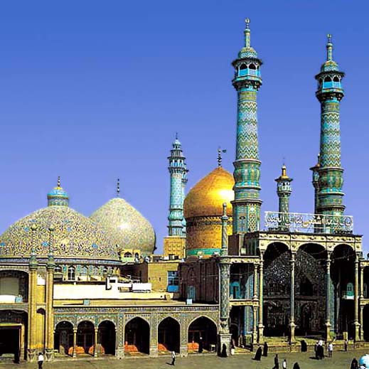
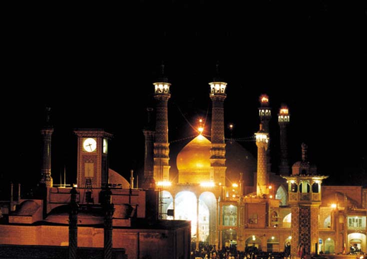
Hazrat Ma'soomeh Holy Shrine, Qom
The aggregate of the Holy Shrine of Hazrat Ma'soomeh is in the city center of Qom, and is considered to be one of the largest and most valuable relics of Islamic architecture of Iran and the world which bears precious remnants from various centuries. This aggregate has been constructed on mausoleum of Hazrat Fatemah reputedly known as Ma'soomeh the daughter of Imam Moosa Kazem (AS), and sister of Imam Reza (AS).
After Hazrat Ma'soomeh's sacred corpse was laid to rest, Moosa Ebne Khazraj erected a straw mat shelter over the tomb. This disintegrated with the passage of time and later the inhabitants constructed a tower like structure made of plaster and brick on the sacred tomb. This was the reason that when any woman from Moosa Ebne Mabraqeh household was passed away, the was buried alongside the sacred tomb of Hazrat Ma'soomeh, thus a cupola was formed which was the burial site of four persons. In due time two other cupolas were erected alongside the prior ones. In the year 447 AH., Mir Abol Fazl, the minister of Toqrol, who was a pious person erected a cupola rising to the height of 14 m. upon the same three other cupolas.
In the Safavid period, the Holy Shrine of Hazrat Ma'soomeh had four courtyards placed in succession, and pilgrims used to enter from one and exit from the other. In Qajar era, Fathali Shah paid special attention to this sacred vicinity and most of its current adornments are related to the said period. Presently the Holy Shrine consists of the following structures:
The sacred shrine: The current structure was constructed by Shah Begum in the year 925 AH. It is an irregular octagon with eight platforms. After this part there is the dome and ceiling adorned with decorative arches. There is a beautiful inscription throughout engraved in the 'Tholth' script in a gilded form on a background of turquoise and white tiles. These verses are sacred. There is also another inscription in embossed 'Tholth' script and worked with plasterwork with verses from the Holy Qoran. This inscription belongs to the date of 1251 AH. On the structure is the dome rising to an elevation of 16 m. which was constructed by the orders of Fathali Shah in place of the former dome in the years 1215-1218 AH. Hazrat Ma'soomeh Holy Shrine
Due to the fact that the sacred tomb is placed between two sepulchres today, is hidden from sight. This tomb is worked with beautiful tile work in the mid 7th century AH., and such adornment is worthy of praise and an excellent piece of craftsmanship. To the south of which after crossing the southern porch, there is a large dome, and this area is commonly known as the 'woman's courtyard', and now is called the 'mosque museum'.
The domed ceiling and altar are worked in artistic tile work, besides the epigraphs which adorn it. In the northern direction of this is the gold porch, constructed by the efforts of Shah Begum, the daughter of Shah Esmail in the year 925 AH. This porch has tile worked cornices related to the Safavid era and two minarets. To the east of the shrine is also a porch reaching a height equivalent to the gold porch known as the 'Mirror Porch' and the said displays a fine master piece of art and architecture of the Qajar period. Facing this porch is a covered area which excels in beauty.
The new courtyard: The same is located to the east of the shrine, and was constructed by Mirza Ali Asqar Khan Amin-ol-Soltan. Surrounding this courtyard are more than 30 large and small mausoleums, the most important of which is his tomb. This courtyard is in two connected segments. The larger sector is an irregular octagon, and the smaller section is in form of a projection amidst the eastern side and is of five sides. Hazrat Ma'soomeh Holy Shrine
Around the courtyard to the upper portion of the porches there are inscriptions of sun baked brick tiles with azure backgrounds displaying poetic verses. This courtyard, besides its mirror porch has three other porches to the east, north and south. The eastern porch is the most delicately architectured of the three. Its ceiling is worked in an arched style adorned with gilded and colored tiles. On this porch are two minarets and a clock tower. The porch was flanked by two corridors which currently are used as vaults. The new court has three tiled entrances to the east, north and south of the courtyard.
The Atiq or old courtyard: This courtyard was built under the instructions of Fath Ali Shah Qajar, in place of the two smaller courtyards of the Safavid era.To the south of this vicinity is the gold porch with porches on two sides of it. On the other sides there are mausoleums, such as that of the two Qajar sovereigns. Surrounding this courtyard and on the porches are inscriptions with poetical verses inspired by the decorative dome in the year 1218 AH. In this courtyard, to the north, is its majestic entrance from the Shah Tahmasb Safavid reign, which is near the Qiasieh School. The northern porch of the courtyard has a vaulted ceiling, but is simple in style otherwise being constructed of gypsum. This is opposite the gold porch. The southern porch however, is a fine relic of the Safavid period adorned with poetical inscriptions.
Tombs of the monarchs: In this aggregate there are various tombs belonging to that of monarchs and princes of the Safavid and Qajar periods. These remnants are considered the historical and artistic relics of this vicinity.
Semnan
Arg Gate (Darvazeh Arg), Semnan
The said gate-way is located at the cross-roads of Ayatollah Talleqani Ave., and Sheikh Fazlollah Noori Ave., of Semnan. This was constructed during the reign of Naseredin Shah, in the years 1300-1305 AH. The gate-way has been made of brick and stands to an elevation of over 7 m. The ceiling of the chambers resemble a barrel, but the main rooms have ceilings covered with shallow domes. The master-piece of this structure is the door way, worked with pieces of seven-colored tiles depicting a scene from the myth of Rostam and the white monster.
The inscriptions of the above mentioned structure are the works of the famous personality of Semnan, by the name of Seyed Mohammad Baqer Tabatabaie Semnani. The doors of the gate-way are of thick planks of wood studded with iron spikes. After the Islamic revolution, this monument was repaired by the Cultural Heritage Organization of the province.

Forests and Deserts, Semnan
The forests areas of the province are the natural forests located in the northern fringes which are the continuation of the mountainous forests of the Alborz mountains, the juniper forests on the southern skirts of the Alborz range with tall and dense trees, the desert forests situated in the vicinity of Chah Jam and Khar Tooran with tamarisk trees. Artificial forests that come under the category of parks alongside the cities. In addition to which the entrance and exit routes of the province have also been manually planted for about 160 km.

Sistan Va Baluchestan
Iran Shahr Old Castle, Iran Shahr
The said castle was a seat of power or command in the past in Baluchestan. It is a brick construction, built during the reign of Naseredin Shah by Firooz Mirza in the year 1264 AH.
Tehran
Azadi Square, Tehran
This structure was constructed in the year 1350 (1971), during the reign of Mohammad Reza Pahlavi in west of Tehran (at the entrance to Tehran - Karaj special Road) on a piece of land with an area of 50,000 sq. m. At the same time a museum had also been constructed in the same building. The basement of the tower encompasses 400 sq. m. and the tower is 45 m. high from ground level.

Iran National (Bastan) Museum, Tehran
This National Museum also known as �Iran Bastan Museum, covers an area of 2,744 sq. m. and is the first scientific museum of Iran which exhibits relics from the 6th millennium BC till the Islamic era. It was constructed in the year 1935 - 11937. This two storeyed museum comprises of halls for speeches, exhibition and a library,etc.
In first floor of museum pre-historical and historical relics are displayed. The second floor contains remnants of the Islamic era. The said museum was closed for basic repairs till the year 1987. At the same year it was inaugurated as "National Museum of Iran". The most valuable pieces displayed here are Qorans from the 3rd-13th century AH, a collection of 61 gold coins from the Samanid and Al-e-Buyeh eras as well as a collection of silver coins belong to the Samanid, Al-e-Buyeh and Qaznavi periods etc.
This museum has a collection of books and publications in various languages, in the fields of Iranian art, archeology, history and also literature relative to the neighboring countries.
Sepahsalar (Shahid Motahari ) Mosque and School, Tehran
This relic of the 13th century AH. is located in Mostafa Khomeini Avenue. The founders of this mosque were Haj Mirza Hassan Khan Sepahsalar (Chancellor of Naseradin Shah Qajar) and his brother Moshirodoleh. The school is 62m. in length and 61 m. in width and has 60 chambers. The dome is 37 m. high. The structure comprises of chambers, porticos, corridors, a two storeyed building, a large dome, minarets , palace for nocturnal prayers (Shabestan), a reputable library and a gateway
West Azarbayijan
Orumieh Lake, West Azarbayjan
The province of West Azarbayjan has the largest lake of Iran in its territory, known as Lake Orumieh. This lake is at an altitude of 1,267 m. from the sea level, with a length of 130-140 km, the width being approximately 15-50 km. and at an average depth of 50-60 m. Its waters are extremely salty (twice the salinity of the oceans), consequently the lake never freezes.
From olden times, local physicians made use of the water (because of its mineral content) and coastal sludge, in treating skin diseases and rheumatoid disorders. The best season for bathing in these waters are from the end of June till the third week of August, when the lake begins getting cold.
Lake Orumieh has numerous islands, both large and small totaling to 102 in number. The most important of these being the following, Kaboodan (Qoyoon Daqi), Ashk, Espeer, and Arezoo.
Kaboodan Island: This island is one of the largest islands of the lake Orumieh, located to the east of which and covering an area of about 3,175 hectares. Its vegetation being generally short scrubs and a variety of trees bearing wild fruits and nuts. Mammals such as wild goat and wild sheep exist on this Island. It is protected by the Department of the Environment as a National Park. Kaboodan Island
Ashk Island: This island lies to the south of the Island of Kaboodan and 40 km. from the port of Golman Khaneh. This island has a 'sweet water' spring and provides a natural habitat for resident and immigrant birds. One of the rarest species of wildlife known as the 'Iranian follow deer' is found here. The Island covers and area of 2,115 hectares and its vegetation is similar to that of the Island of Kaboodan.
Espeer Island: This island covers an area of 1.151 hectares, located to the west of the Kaboodan island and 27 km. from the port of Golman Khaneh. This island provide a natural habitat for birds. The island also has one jetty. These islands have facilities for swimming and water sports.
  
 
Takht-e-Soleiman Castle, Takab
The aggregate of the Takht-e-Soleiman monument is placed on a natural high land, about 20 m. above the surrounding plain. All the structural relics have been constructed within an oval shaped rampart. The exterior rampart with 5 m. thickness, 14 m. height and outer circumference of 1,200 m. has 38 conical defense towers.
The outer wall is a remnant from the Sassanian period. During the Ilkhanan reign, a new gateway had been constructed adjoined with the former southern gateway. Within the oval rampart there are two square plots, with uniaxis and different centers. In the centers of the southern square there is a lake and the northern square an ancient fire-temple respectively. Eivan-e-Khosrow is placed to the north western direction of the lake and to its southern side is Eivan-e-Garabaq-e-Khosrow. Takht-e-Soleiman was destroyed during the Roman conquest in 624 AD.
In archeological surveys around the area of the fire-temple a variety of coins, tiles and a huge copper cooking vessel (a remnant of the Islamic period), have been discovered. The Soleiman prison which consists of the remnants of a pre-historic and the Medes temple is included in this aggregate. Sites such as dormant volcanoes, thermal springs and streams around Takht-e-Soleiman are worth surveying.
  
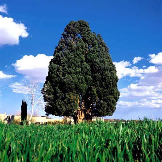
Yazd
Abar Kooh
The town of Abar Kooh is located in the southwest of the province. In decades back, this town was a part of Abadeh in Fars province, and after joining Yazd province this section changed to a city. Abar Kooh is an area in a desert which has a very warm climate. The economy of this region is based on agriculture, laboring, carpet weaving. The agricultural products of Abar Kooh are wheat, barley, sugar beet, cotton, oil seeds etc. The fruit trees are mulberry, grapes, apples, and apricots. Many years ago, Abar Kooh was called Abarqoyeh and Barqoyeh and in 1975, its name was changed from Abarqoyeh to Abar Kooh.
4000 Years Old Cypress Tree
Abar Kooh is a very ancient and was a florishing city, situated on the way of Silk Road. The name of Abar Kooh is mentioned in the books of Islamic geographers like Fars Nameh of Ebne Balkhi, Nazhate-Al-Qolub, Haft Eqlim, and Fars Nameh of Naseri, etc.
Chak Chakoo Fire Temple, Yazd
It is a place located amongst the mountains of Ardakan and Anjireh (on the way to Tabas) which is at a distance of 46 kilometers from Yazd. Chak Chakoo has its name for the water dripping from the stone-cut mountains. This vicinity has suitable accommodation for pilgrims.
 
Mir Chakhmaq (Amir Chakhmaq) Mosque, Yazd
The same is reputedly known as the Jame' Nou Mosque. The mosque is a relic of the Safavid period, and was constructed by Amir Jalaleddin Chakhmaq Shami and his spouse Fatimeh Khatoon (Seti Bibi). Amir Chakhmaq was the governor of the time in Yazd, and one of the Teimoorids commanders, who was held in high esteem by the monarch Shahrokh. The mosque was completed in the year 841 AH. On the threshold of the mosque, is a carved inscription in the Naskh script, revealing a deed relevant to the endowment, on the eastern entrance of the mosque is a tiled epigraph with the Tholths scrip. Around the dome of the said structure is an inscription adorned with the cuneiform or Kufic script.

Yazd
The city of Yazd is located to the north of Ardestan, to the south of Taft in the east of Bafq and to the west of Esfahan province. Yazd is the center of the province and is located 689 kilometer from Tehran. It is located in an extensive valley facing the desert. Consequently, its weather is hot and arid in summer and cold in winter, which are some specifications of the weather of this territory. In the 5th century AH.coinciding with the settlement of the sons of Abu-Jafar Kakoo in Yazd, the development of this city began, and the walls of Yazd were constructed. The Atabakans, took an interest in development of the city of Yazd constructed many schools and mosques.
During the Al-Mozaffar era many villages and underground canals were constructed. During the Mongol invasion many scholars and artists of the 7th and 8th century settled in this city for more protection. They chose this city as a center for their scientific and artistic activities. At that time many mosques and schools were built.
Several monasteries (praying sites of the Sufis) in the city reveals that this region was considered to be a shelter for Sufis and Gnostics. Some of the monasteries like those of Sheikh Ali Soleiman in Bidakhid, the monastery and mosque of Sheikh Dada in Bonder Abad and the monastery of Sheikh Ahmad Fahadan in Yazd are still present today. Furthermore, the city of Yazd has various historical sites in charming deserted areas worth visiting

Zanjan
Soltanieh Dome Tomb, Abhar
The said lies south west of the Cohan Dej (Royal citadel). It was constructed during the reign of Soltan Mohammad Khoda Bandeh (Oljaito) in the years 704-712 AH. This structure has 8 elevated porticos and about 50 chambers, including an area which is also similar to a chamber. The dome of this construction weighs 200 tons and is situated on pillars, bearing an area of 50 sq.m. each if separated or cut across. This structure is made of a mixture of gypsum and to a lesser proportion limestone. Gonbad Soltanieh is erected in three floors which are defined as follows. The ground floor consists of the eight portions. The first floor comprises of the halls which run throughout this floor.
On the third floor is the foundation column of the dome and the octagonal pillars supporting the minarets. The entrance to the cellar is from the southern portico. The layout or plan of this cellar is a complex one, consisting of 7 segregated sections, each part independent of the other. The principle factors regarding the artistic effects revealed in Gonbad Soltanieh are the inlayed brick-work, plaster moldings, engravings and tile works. All these together create harmony that is worth appreciation and artistic value. For example, the spectacular engraving here that stands 360 cm. high in which a verse from the Holy Qoran (Sureh Fath) has been inscribed in the beautiful script of 'tholth'.
On the upper or second floor of this structure engravings can also be observed, one of these inscribed with the (Ayeh 125 Sureh Mobarakeh Baqareh) from the Holy Qoran inscribed in the "Kufic' script.
 
|
|